Cebu.travel
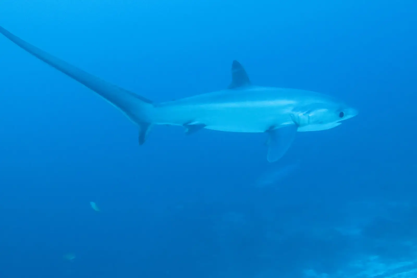
A pelagic thresher shark with its long tail swimming in blue water off Malapascua
Far north, Visayan Sea

Diving Malapascua, Gato Island & the thresher shoals

Malapascua, a small island off Cebu’s northern tip, is where divers go for pelagic thresher sharks. They visit a cleaning station on a sunken plateau in the morning, and in 2022 they moved from Monad Shoal to Kimud Shoal, about an hour by boat (now a Leyte-declared marine protected area). Around the island are some 25 easier reef sites, Gato Island’s sea-snake sanctuary and 30 m tunnel, and the Tapilon and Doña Marilyn wrecks. Getting there means a 4-4.5 hour drive to Maya port and a 30-minute boat.

Quote a transfer to Maya port Last checked: Oct 2026
Dive sites here
38 (29 mapped)
From Cebu City
~133 km to Maya, 4-4.5 hrs + 30-min boat
Threshers
Year-round, now at Kimud Shoal
Thresher depth
~12-15 m at Kimud
Last boat from Maya
About 5 PM, no night crossing
Water
~25-27°C Jan-Feb, 28-30°C rest of year

Monad Shoal is still dived (one operator reported regular tiger shark sightings there in 2026), but threshers are now rarely seen at Monad. At Kimud they are seen shallower, at about 12-15 m, and later in the morning, so the old pre-dawn start is no longer essential.

Malapascua is part of barangay Logon in Daanbantayan, about 2.5 by 1 km, and has been a dive destination since the early 1990s. Monad Shoal and Gato Island together were declared the Philippines’ first shark and ray sanctuary.

Map of Malapascua dive sites

Map of Malapascua dive sitesAccurate map of the Malapascua, Gato Island & the thresher shoals area with 25 dive sites marked.NMaya portChocolate IslandMonad ShoalKimud ShoalTapilon WreckMogami MaruGato Island

Close-up: Around Malapascua Island

Close-up map: Around Malapascua IslandClose-up of Around Malapascua Island with its dive sites marked.NLapus LapusBugtong BatoQuilianoDeep RockDeep SlopeBantigueKa OstingDakit DakitUbang BatoLos BamboosLighthouseEvolution house reefExotic house reef

Close-up: Gato Island

Close-up map: Gato IslandClose-up of Gato Island with its dive sites marked.NGuardhouseThe CaveThe WallWest

Tap a dot or a site in the list. 4 day-trip sites sit beyond this map: see the list.

38 dive sites

Malapascua dive sites at a glance

SiteDepthLevel
Around Malapascua
Lapus Lapusto 17 mBeginner
Lapus Lapus 212-20 mBeginner
Lapus Pinnacle10-23 mBeginner
North Point6-27 mBeginner
North Wallto 24 m-
Bugtong Bato12-30 mIntermediate
Quiliano12-25 mBeginner
Deep Rock14-30 m-
Deep Slope12-25 mIntermediate
Bantigue6-18 mBeginner
Ka Osting3-15 mBeginner
Dakit Dakit5-20 mBeginner
Ubang Bato15-30 mIntermediate
North Rock15-21 mBeginner
Pawikan Hole10-25 mBeginner
Secret Wall--
Los Bamboos--
Lighthouse3-12 mBeginner
Evolution house reefto 20 mBeginner
Exotic house reef5-15 mBeginner
Chocolate Island3-17 mBeginner
Thresher shoals
Monad Shoal12-40 mIntermediate
Kimud Shoal12-29 mIntermediate
Gato Island
Guardhouse (Gato Island)to 24 mBeginner
The Cave (Gato Island)5-24 mIntermediate
The Wall (Gato Island)to 21 mBeginner
West (Gato Island)to 22 mBeginner
Whitetip Alley (Gato Island)to 24 m-
Nudibranch City (Gato Island)to 22 m-
Cathedral (Gato Island)to 22 m-
Wrecks
Tapilon Wreck22-29 mIntermediate
Mogami Maru42-56 mTechnical
Doña Marilyn Wreck17-35 mIntermediate
Day trips
Maria Islandto 22 mAdvanced
Calangaman Island5-50 mIntermediate
Sambawan Island12-30 m-
Buhoc Pointto 30 m-
Maripipito 30 m-
Site by site

Every Malapascua dive site

Depth, level, access, marine life and current for each site, with its sources. Every site has its own link, so you can share one directly.

Around Malapascua

Lapus Lapus

Beginner
Logon, Malapascua Island, Daanbantayan · also called Lipus Lipus
Depth
to 17 m
Access
Boat
Type
Reef
  • Soft coral garden off the far northwest tip of the island
  • Giant and painted frogfish
  • Smashing mantis shrimp, cleaner shrimp, glassfish and nudibranchs
  • Current: Usually low, though strong currents feeding the soft corals are also described.
  • Depth: Maximum about 17 m to 18 m
Macro

North Point

Beginner
Logon, Malapascua Island, Daanbantayan
Depth
6-27 m
Access
Boat
Type
Reef
  • Scorpionfish, frogfish and lionfish
  • Zebra crabs, candy crabs and other fire urchin hitchhikers
  • Current: Medium to strong currents of 1 to 2 knots.
  • Level: Used for Open Water training
  • Depth: Maximum about 22 m to 27 m
Macro
Logon, Malapascua Island, Daanbantayan
Depth
to 24 m
Access
Boat
Type
Wall, Drift
  • A short wall at 24 m, about 10 m long and 6 m high
  • Giant frogfish and nudibranchs
  • A sandy field of sea pens, finished as a drift
  • · About 5 minutes by boat
DriftMacro

Bugtong Bato

Intermediate
Logon, Malapascua Island, Daanbantayan · also called Bogtong Bato, Butong Bato
Depth
12-30 m
Access
Boat
Type
Reef, Wall
  • A seamount just off the north end of Malapascua; the name means the only rock
  • Schooling batfish and squid
  • Harlequin shrimp
  • Sea fans at 25 m to 30 m where Bargibant pygmy seahorses can be found
  • Current: Can have currents.
  • Level: Listed for Open Water divers, and also described as a slightly more advanced dive because of currents
Macro

Quiliano

Beginner
Logon, Malapascua Island, Daanbantayan · also called Quilliano, Guilliano
Depth
12-25 m
Access
Boat
Type
Reef, Wall
  • Pygmy seahorses on the sea fans
  • Frogfish
  • Spearing mantis shrimp
  • Current: Sometimes strong.
  • Depth: Maximum about 20 m to 25 m
Macro

Ka Osting

Beginner
Logon, Malapascua Island, Daanbantayan · also called East Garden
Depth
3-15 m
Access
Boat
Type
Reef
  • One of the closest sites to the island
  • Bobtail squid, decorator crabs and hairy frogfish
  • Octopus and cuttlefish
  • Blue-ringed octopus on night dives
Night diveMacro

Dakit Dakit

Beginner
Logon, Malapascua Island, Daanbantayan
Depth
5-20 m
Access
Boat
Type
Reef
  • Known for nudibranchs
  • Banded pipefish, seahorses and cuttlefish
  • Orangutan crabs
  • Boulders at 8 m to 15 m
  • Current: Can have strong currents.
  • Depth: Usually 12 m to 15 m, up to 20 m
Macro

Lighthouse

Beginner
Logon, Malapascua Island, Daanbantayan · also called Lighthouse Reef
Depth
3-12 m
Access
Boat
Type
Reef, Wreck
  • Mandarinfish mating at dusk
  • Bobtail squid and seahorses
  • Blue-ringed octopus
  • A small wreck with barracuda, octopus and pipefish
  • Depth: Reef at 5 m to 12 m; the small wreck lies at 3 m to 5 m
  • · In front of the lighthouse on the northwest side of the island
  • · A WWII Japanese landing craft, broken in two, lies here in 3 m to 5 m and is used for first wreck dives
  • · Divers use red lights only for the mandarinfish dive
Night diveMacro
Maya, Daanbantayan
Depth
3-17 m
Access
Boat
Type
Reef, Muck
  • Small island between the tip of Cebu and Malapascua
  • Flamboyant cuttlefish and blue-ringed octopus
  • Sea snakes, snake eels, seamoths and dragonfish
  • Hairy frogfish and Spanish dancers
  • Current: Sometimes strong.
  • · About 20 to 35 minutes by boat from Malapascua
Macro

Thresher shoals

Monad Shoal

Intermediate
Off Malapascua Island, Daanbantayan · also called Shark Point
Depth
12-40 m
Access
Boat
Type
Shoal, Wall
  • Long known for thresher sharks at dawn, though since about 2022 they are only rarely seen here
  • Manta, devil and eagle rays
  • Tiger sharks reported at the cleaning station
  • A flat-topped shoal on the edge of a drop past 200 m
  • Current: Often low, but surface currents can be strong on some days.
  • Level: Usually listed for Advanced Open Water divers, sometimes for Open Water
  • Depth: The top is at 12 m to 24 m; the edge drops past 200 m
  • · Marine protected area since 2002 (1.8 sq km plus a 500 m buffer); with Gato Island it was made a shark and ray sanctuary by a 2015 executive order
  • · About 7.8 km and 30 to 35 minutes by boat from Malapascua
  • · A ship ran aground here in June 2016 and damaged about 3 ha of the shoal
SanctuaryBig animals

Kimud Shoal

Intermediate
Dived from Malapascua; jurisdiction Tabango, Leyte · also called Kemod Shoal, Kimod Shoal, Kimut Shoal
Depth
12-29 m
Access
Boat
Type
Shoal, Wall
  • Thresher sharks at the cleaning stations most mornings since about 2022, when they moved here from Monad Shoal
  • Schooling hammerheads, most likely December to April
  • Other pelagics
  • Level: Open Water divers go with a guide and may be asked to do a buoyancy workshop first; some centres ask for Advanced Open Water.
  • Depth: Plateau at about 12 m to 15 m, cleaning stations at 12 m to 22 m; the shoal goes to about 50 m
  • · Declared a marine protected area by Tabango, Leyte on 6 Feb 2026
  • · About an hour by boat from Malapascua, usually as a multi-dive trip
  • · No flash or strobes around the sharks
SanctuaryBig animalsIn Leyte waters

Gato Island

Gato Island, Daanbantayan · also called The Guardhouse, Houseguard
Depth
to 24 m
Access
Boat
Type
Reef, Sanctuary
  • Large rocks covered in gorgonians
  • Pink and yellow pygmy seahorses
  • Spider crabs and cowries
  • Depth: Maximum about 20 m to 24 m
  • · Starts by the guardhouse on the northeast side and heads south along the island
  • · Gato Island has been a sea snake and fish sanctuary since 1997
SanctuaryMacro
Gato Island, Daanbantayan · also called Gato tunnel, Cavern
Depth
5-24 m
Access
Boat
Type
Cave, Reef
  • An L-shaped tunnel through the island
  • Whitetip reef sharks near the exit
  • Banded sea kraits, catsharks and crabs
  • Level: Listed for Advanced Open Water divers, and also described as for experienced divers only
  • Depth: Tunnel entry at about 5 m and exit at about 12 m; maximum about 20 m to 24 m
  • · The yellow-lipped sea krait here is venomous; keep your distance
SanctuaryBig animals

Wrecks

Tapilon Wreck

Intermediate
Tapilon, Daanbantayan
Depth
22-29 m
Access
Boat
Type
Wreck
  • Large marble rays
  • Moray eels, cuttlefish and squid
  • Flatworms and nudibranchs
  • Current: Medium, 1 to 2 knots.
  • Level: Listed for Advanced Open Water divers
  • · An unidentified WWII Japanese cargo ship, torpedoed and lying in several sections
  • · About 30 minutes by boat from Malapascua
Big animals

Mogami Maru

Technical
North of Malapascua Island · also called Pioneer Wreck
Depth
42-56 m
Access
Boat
Type
Wreck
  • Sits upright on sand with a swim-through along the starboard side
  • Yellow cup corals
  • Artefacts on board such as cutlery
  • Current: Medium; only dived when the tides are right.
  • Level: A technical dive only
  • · Described as a Japanese trawler converted to a submarine chaser and sunk by a US bomber on 12 Sep 1944
  • · The wreck's identity is disputed
Dived from Malapascua, 60 to 90 minutes by boat
Depth
17-35 m
Access
Boat
Type
Wreck
  • A passenger ferry lying on its starboard side
  • Marble rays, blue-spotted rays and whitetip reef sharks
  • Black coral, cardinalfish and flasher wrasse
  • Level: Listed for Advanced Open Water divers
  • Depth: Maximum about 32 m to 35 m
  • · The ferry capsized in Typhoon Ruby on 24 Oct 1988; about 400 people died or went missing
  • · Illegal salvagers tore off part of the stern in 2018
Big animals

Day trips

Calangaman Island

Intermediate
Palompon, Leyte · also called Kalanggaman, Kalangaman
Depth
5-50 m
Access
Boat
Type
Wall, Reef
  • Steep walls with black coral, hard corals and gorgonian fans
  • Sharks, rays, tuna and barracuda
  • Turtles and an occasional thresher shark
  • Pygmy seahorses and ornate ghost pipefish
  • Level: Usually listed for Advanced Open Water divers, sometimes for Open Water
  • Depth: Reef top at 5 m to 10 m; walls drop past 40 m
  • · About 90 minutes to 2 hours by boat from Malapascua
Big animalsMacroIn Leyte waters
Biliran · also called Sambowan
Depth
12-30 m
Access
Boat
Type
Reef
  • Blacktip reef sharks and barracuda
  • Beaked coralfish and Bartlett's dragonets
  • Denise pygmy seahorses
  • An isolated area that is rarely dived
  • Depth: Top of the shelf at about 12 m
  • · About 3 hours by boat from Malapascua
Big animalsMacroIn Biliran waters
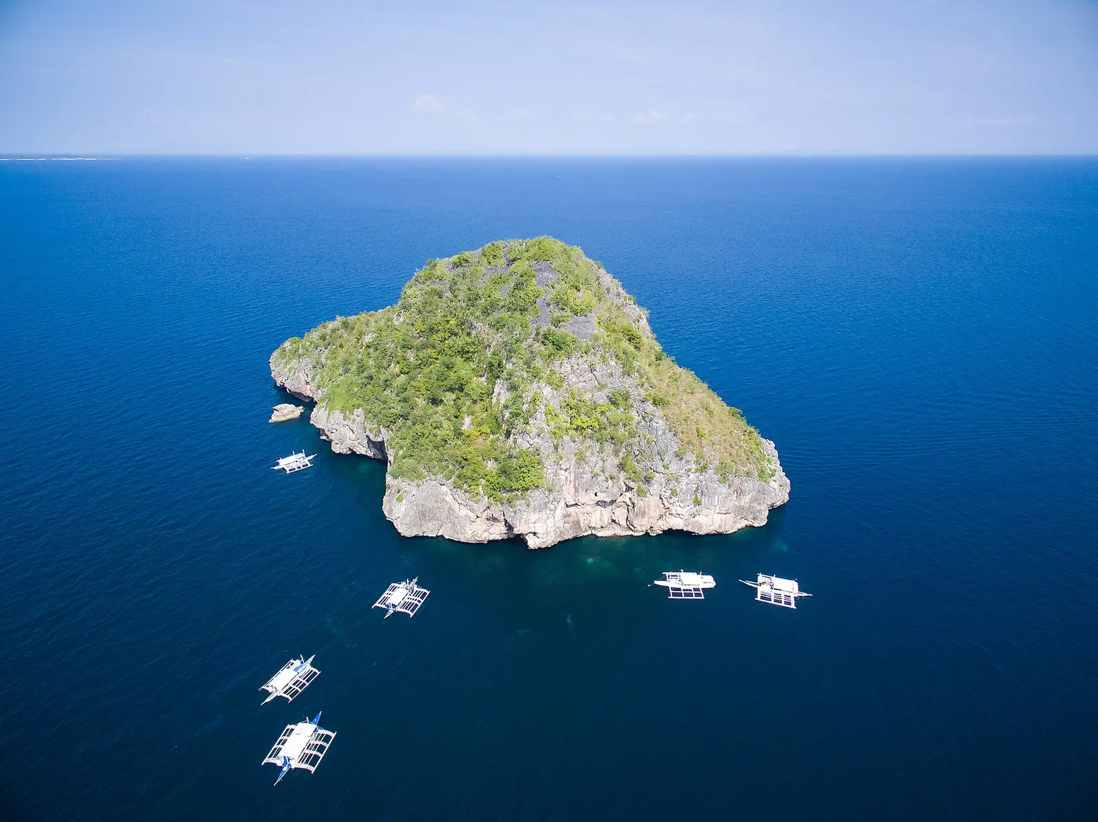
Aerial view of Gato Island with dive boats moored nearby
Gato Island, a sea-snake sanctuary
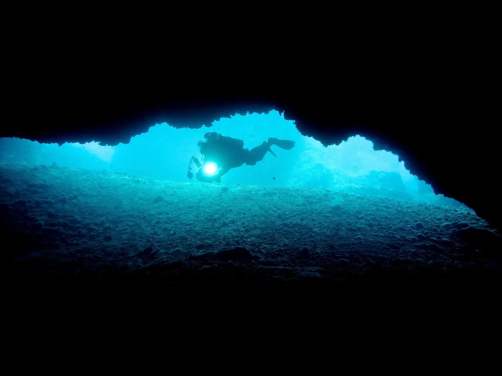
A diver silhouetted in the tunnel through Gato Island
Inside the Gato tunnel
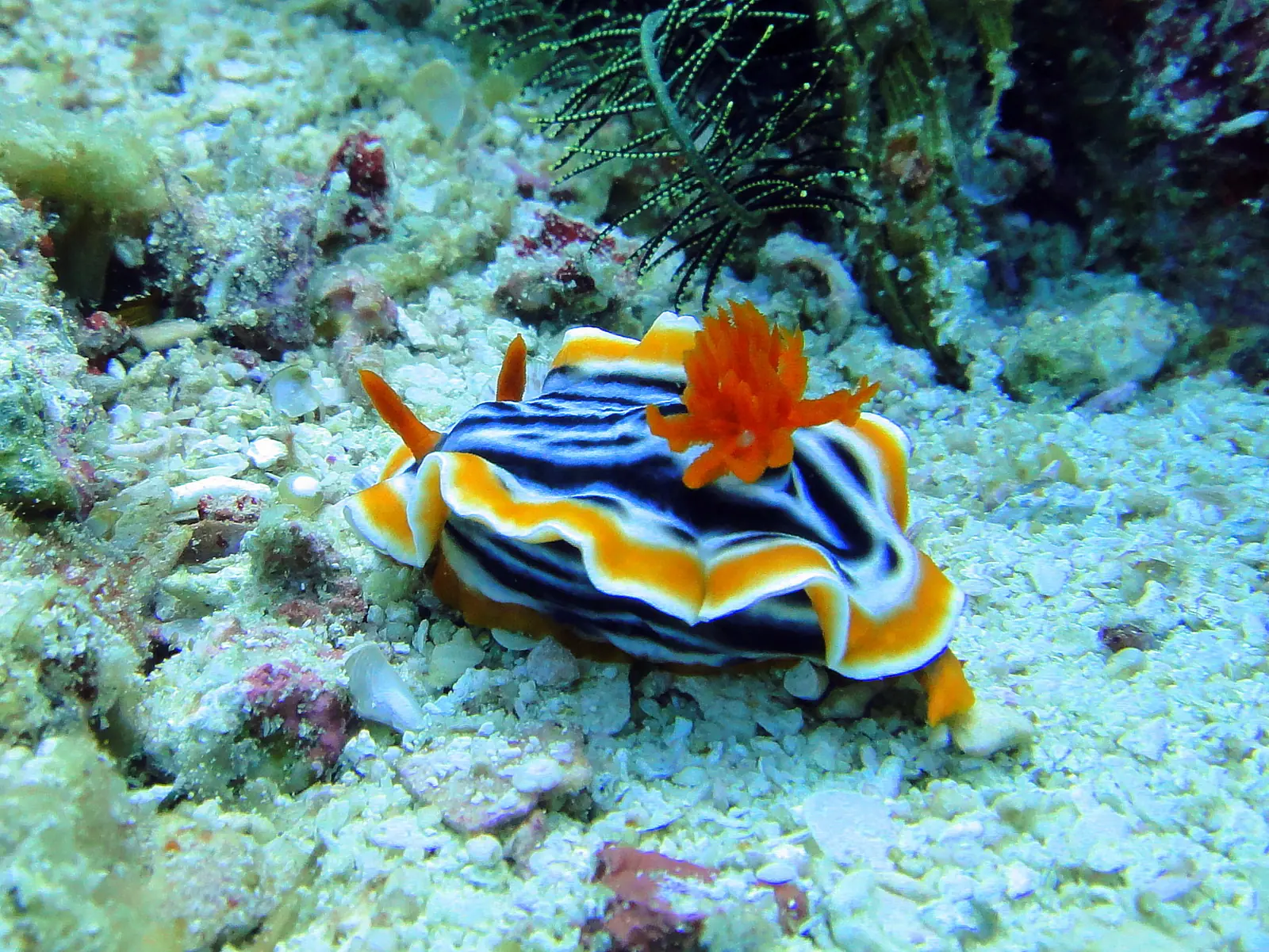
A brightly coloured pyjama chromodoris nudibranch on the reef at Malapascua
Macro around Malapascua
When to go

Seasons and conditions in Malapascua

Malapascua diving seasons
ThreshersAll year
Best weatherMarch to May; January to June usually good
RougherAugust-September can be bad; October-December a little worse
VisibilityKimud 20-30 m in March-May; 10-15 m common on rough north-east monsoon days
Coolest waterJanuary-February, about 25-27°C

Local rules and fees

  • Shark and ray sanctuary

    Daanbantayan Executive Order 16 (2015) made Monad Shoal and Gato Island a shark and ray sanctuary, banning the catching and trade of all sharks and rays there.

  • Kimud Shoal (Tabango, Leyte)

    Declared a marine protected area by Tabango, Leyte on 6 February 2026. Open Water divers are reported to need a buoyancy workshop before the dive, and flash photography is not allowed.

    Source: mnlmag.com, 3 Sep 2026
  • Island and dive fees

    An environmental fee is collected at Maya for the crossing, and divers pay marine-park and shoal fees through their operator. Published amounts vary between sources, so we print none.

    Source: malapascua-diving.com, 13 Oct 2026
Getting there

How to get to Malapascua with your dive gear

Getting to Malapascua
RoadAbout 133 km and 4-4.5 hrs from Cebu City to New Maya port in Daanbantayan, or about 145 km and 4.5-5 hrs from Mactan airport. Ceres buses from the Cebu North Bus Terminal take 4-5 hrs.
BoatPublic boats from Maya take about 30-35 minutes, leave when full and stop at about 5 PM. There is no night crossing, so plan the drive back from the last boat.
Kimud & GatoKimud Shoal is about an hour by boat from Malapascua; Gato Island about 50 minutes.

Dive kit takes more room than its bag count suggests, so tell us how many gear bags you are bringing and we size the vehicle for it before we quote.

Quote only · no invented prices

Quote a transfer to Maya port, gear included

A private car or van with room for your dive bags, met at arrivals or your hotel, at one fixed price agreed before you travel. We reply by email, usually the same day.

We’ll pre-fill Maya Port (Daanbantayan) on the form - just add your dates and details.

FAQ

Diving Malapascua: questions

Are the thresher sharks still at Monad Shoal?

Rarely. Since 2022 the threshers have used Kimud Shoal, about an hour by boat from Malapascua, and are only occasionally seen at Monad. Kimud is in Leyte waters and was declared a marine protected area by Tabango on 6 February 2026. Dive operators on Malapascua run the Kimud trip as a two- or three-dive day.

Do you need to be an advanced diver to see the threshers?

Not at Kimud, where the sharks are usually seen at about 12-15 m. The shoal is still open water with a drop-off, and Open Water divers are reported to need a buoyancy briefing first. Monad Shoal’s plateau sits at about 20 m, deeper than an Open Water card allows.

Can I fly the day after diving Malapascua?

Plan on it rather than the same day: Divers Alert Network guidance is at least 18 hours before flying after several days of diving. Dive your second-to-last day, take a daytime boat back to Maya on your last, and let the drive south fill the gap.